Introduction
The Arctic is the region of the Earth where the strongest temperature rise has been observed. It is therefore an ideal and important region where the computational models that predict global climate change can be checked against reality. It is our intention to contribute to a better understanding of some of the processes involved in the temperature change in the Arctic. For this purpose, we will conduct airborne measurements in the Canadian Arctic in April and May 2012.
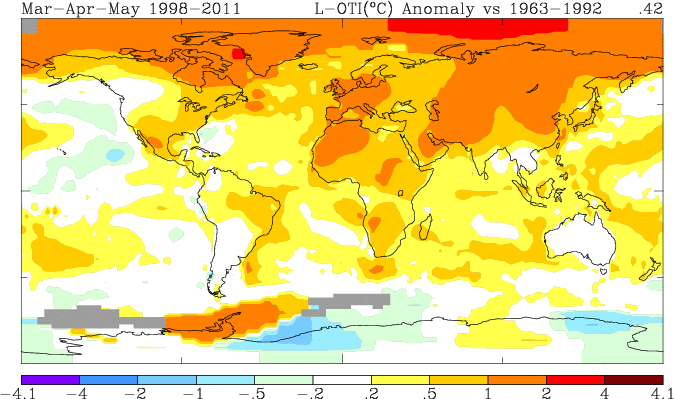 Difference (in degrees Celsius, or Kelvin) in mean springtime temperature between the years 1998-2011 and the years 1963-1992. Source: NASA GISS Surface Temperature Analysis
Arctic Climate Change
Difference (in degrees Celsius, or Kelvin) in mean springtime temperature between the years 1998-2011 and the years 1963-1992. Source: NASA GISS Surface Temperature Analysis
Arctic Climate Change
One of the reasons why the Arctic is so sensitive to climate change is the albedo effect. The surface in the Arctic is usually dark: sparsely vegetated soil, or the depths of the Arctic Ocean. However, the areas covered by snow and ice are very bright. Dark surfaces absorb a large fraction of the incoming solar energy, while bright surfaces reflect most of it back up into the atmosphere. Therefore, dark areas heat up more than bright areas when the Sun shines on them. So if a piece of ice melts and gives way to the underlying dark surface (soil or water), local heating occurs and more ice will melt. This is a positive feedback mechanism because the melting process is self-amplifying.
The amount of solar energy that reaches the surface is mostly controlled by two things: time and clouds. Time is crucial in the Arctic because in winter the Sun does not rise at all for months, while in summer there is no night. Also the high Sun around noon transports much more energy into a square meter of surface than a low Sun near the horizon.
Role of Arctic clouds
In the Arctic, clouds (in particular, boundary-layer clouds) are of special importance in the predictions of Arctic climate warming. On an annual average, the act similar to greenhouse gases: they keep thermal infrared radiation from escaping into space. This effect exceeds the cooling due to the reflection of incoming solar radiation by these clouds. In detail, this radiative effect is highly variable and depends on the surface albedo, aerosol properties, and cloud properties such as water content, cloud-droplet or ice-crystal size, and the thermodynamic phase (ice vs liquid water). Additionally, the long periods of permanent polar day and polar night have a strong impact on the competition between solar and terrestrial radiative effects. For example, the low surface albedo in summer (the dark ocean surface, instead of the bright ice) leads to a seasonal cooling effect of Arctic clouds.
The Earth's total energy budget is defined by the incoming and outgoing
solar and the outgoing
terrestrial (or thermal infrared) radiation. Solar radiation has wavelengths between 0.3 and 4 micrometers (one micrometer is one millionth of a meter, or one thousandth of a millimeter). Terrestrial radiation has wavelengths between 4 and 100 micrometers. Both are modified by scattering, absorption, and emission by atmospheric particles (including cloud droplets), but also by the Earth's surface. The
energy budget of the Arctic differs significantly from that of the entire Earth's global and annual average. The Arctic areas are a major sink in the Earth's energy budget, especially because they receive so little solar energy.
The Arctic regions are highly sensitive to changes in the net solar radiation. Two circumstances increase the impact of atmospheric constituents in the Arctic: the Sun is always low (which increases the optical path of solar radiation, so there is more interaction with the atmosphere), and the surface is very bright (high surface albedo due to snow and ice; the reflected radiation has a second chance to interact with the atmosphere). This results in a high variability of the Arctic climate, as it has been reported in the Arctic Climate Impact Assessment (published by Corell, Cambridge University Press, U.K., 2004). Therefore, it is important to measure the components of the Arctic radiation budget (clouds and aerosols, surface properties, and their interaction with the radiation field), and to validate ground-based and spaceborne remote sensing of Arctic climate parameters, as well as climate models.
A question of perspective
Our knowledge about Arctic boundary-layer clouds largely depends on satellite measurements. Those retrievals are based on radiance at a limited number of wavelengths. However, evaluating the cloud radiative effect and the global energy budget requires knowledge of irradiance over the entire spectral range. The conversion from radiance to irradiance is not straightforward and requires knowledge of the cloud optical properties (which is what is derived from the radiance measurement onboard the satellite). The cloud retrieval itself is inaccurate for several reasons, such as horizontal cloud inhomogeneities, a preselection of the thermodynamic state, a poor representation of ice-crystal properties, and uncertainties in the vertical structure and the underlying surface albedo. In order to test whether climate models can use the cloud properties retrieved from satellites, we need to check how accurately irradiance can be calculated from these cloud properties. This is only possible with combined airborne measurements of radiation (irradiance and radiance) and of cloud microphysical properties.
Our expedition
VERDI (short for
Vertical Distribution of Ice in Arctic Clouds) is a cooperation project of various German research institutes with the goal to measure the microphysical and optical properties of Arctic boundary-layer clouds. The measurements will be conducted on the polar research aircraft
Polar 5 of the Alfred Wegener Institute, Bremerhaven, Germany.
Measurements
The research flights will consist of two types of flight legs, to (a) observe the cloud from above (remote sensing), and (b) to probe the cloud particles flying inside the cloud (in-situ measurements).
During flight legs for remote sensing, solar radiation reflected by the cloud is detected by the instruments on the aircraft. The spectral SMART-Albedometer and the hyperspectral Eagle camera use the Sun as the light source, while the AMALi lidar detects photons from its own laser that are scattered back by the cloud particles. This set of measurements gives us a variety of information:
- The exact distance between the aircraft and the cloud top, determined by the run time of the lidar photons;
- The extinction coefficient of the atmosphere, including aerosols, determined from the amount of lidar backscatter (clouds are usually saturated in this signal);
- The optical depth (total optical extinction) of the cloud, derived from the spectral reflectivity measured by the SMART-Albedometer and the Eagle;
- An estimate for the effective radius of the cloud particles, derived from the near-infrared portion of the solar reflecticity spectrum measured by the SMART-Albedometer;
- The horizontal distribution of the cloud (in terms of optical depth) as observed by the hyperspectral camera Eagle.
As an example, the measurement of the cloud reflectivity by the SMART-Albedometer is described in more detail:
The determination of a reflectivity requires the measurements of two different radiation quantities:
Irradiance and
radiance.
Irradiance is used to quantify the energy budget of solar radiation. It represents the radiant energy flux (Watts, i.e., energy per time) received by a horizontal unit surface. Irradiance therefore bears the unit Watt per square meter.
Radiance is used in remote sensing, it is measured by satellite sensors. It is a directional quantity and represents the irradiance per solid angle (field of view of the sensor). Its unit is therefore Watt per square meter and per steradians. The reflectivity is defined as the ratio of the upward radiance (the radiation reflected by the spot of cloud directly under the aircraft) and the downward irradiance (as a measure of the energy flux that illuminates the cloud), multiplied by pi.
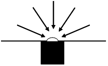

Illustration of irradiance (left) and radiance (right). Irradiance: detection from all directions. Radiance: detection only from a certain solid angle.
Cloud particles can do two things with a photon: they can scatter it into a different direction, or they can absorb it. The likelihood that either of these two processes happens, depends on the wavelength (or energy) of the photon. That is one reason why it is so important to measure the reflectivity with a good spectral resolution. This allows us to gain information about the cloud particles by looking at the reflectivity at two different wavelengths. Each combination of reflectivity values at these two wavelengths corresponds to a certain combination of amount and size of cloud droplets (in terms of optical depth and effective radius) that can be calculated. This is how the hyperspectral camera Eagle can be used to obtain a map of the optical depth of a cloud field.
During the legs for in-situ probing, the aircraft will fly profiles through the cloud layer. The instruments mounted under the wings will detect the cloud particles as they pass through the instrument volume. For example, an ice crystal flies through a laser beam, and the laser light is scattered and diffracted onto the surrounding sensors. The result is a recording of a diffraction patters that contains information about the size and the shape of the ice crystal. A computer can analyze all the recorded diffraction patterns after the flight and create a statistical table about the ice population in the given cloud.
Technical details and the acronyms are explained on the
instruments site (left menu).