| Take Off: | P5 19:36 UTC | P6 19:43 UTC |
| Touch Down: | P5 23:49 UTC | P6 23:35 UTC |
| Duration | P5 4:13 h | P6 3:52 h |
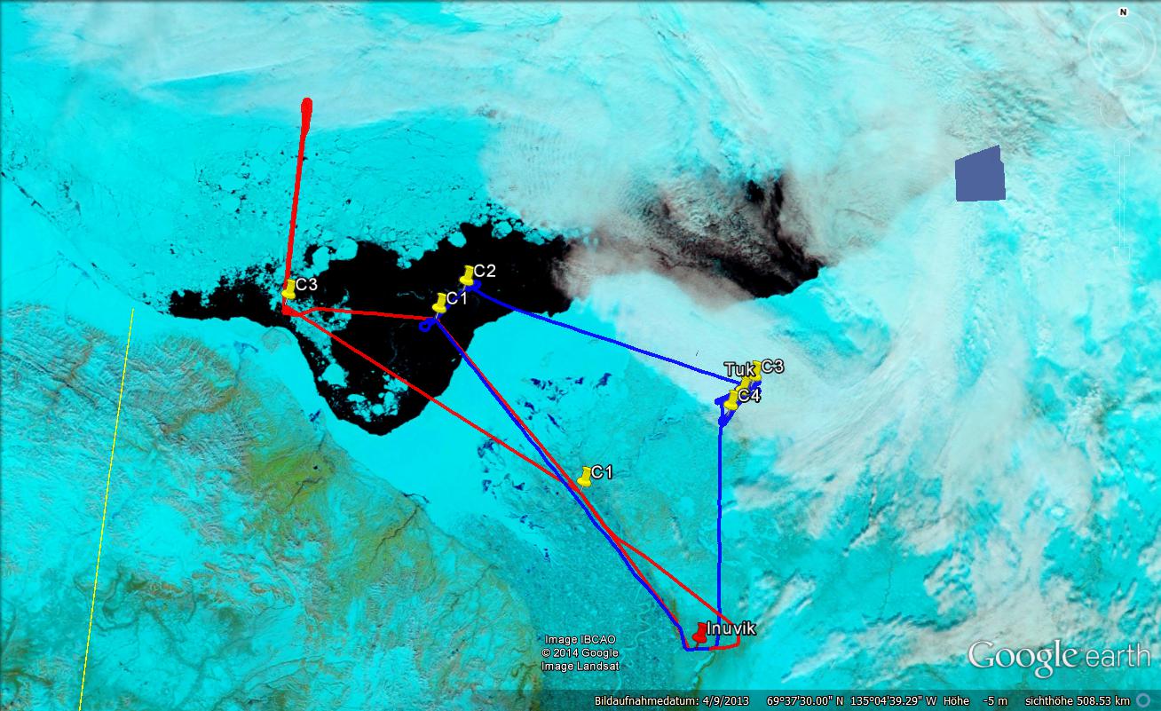
Clear sky conditions were forecasted for wide areas around Inuvik. This was the first chance to perform the clear sky mission as proposed for RACEPAC. Although the satellite images showed a little smaller cloud free area, we found perfect conditions over the Beaufort Sea. As some clouds might appear in the area all PMS probes were operated during the flight. In Polar 5 the configuration of the AMALi lidar was changed for zenith view for this flight. Take-off was scheduled for early afternoon as the cloud free area was forecasted to increase during the day.
The mission of Polar 5 was to measure surface albedo in as much different conditions as possible. A flight altitude of 1,000 ft was chosen for the beginning. Flying low AMALi in zenith configuration measured the aerosol column above the aircraft. During all the flight no significant layers could be detected in the real-time quicklook. The flight path was first directed close to Herschel Island, where the sea ice started to get denser. On the way areas above the Beaufort Sea including the fast ice were sampled. From Herschel Island Polar 5 flew north as long as cloud free conditions continued. Unfortunately, the cloud deck north of 70° N did not vanish a lot during the day. Only about 50 NM north of the start of the leg, a midlevel cloud layer appeared. However, on this leg the density of sea ice significantly increased providing good conditions for the data analysis. We continued for about 5 min flying below the relative homogeneous cloud to sample surface albedo also in case of overcast conditions. After that, Polar 5 returned towards Herschel Island now flying at 500 ft altitude. The same 50 NM leg was repeated twice more at 2,000 ft and 10,000 ft. The different observation altitudes will allow to study how the impact of surface heterogeneity develops with increasing distance between sensor and surface. The last leg at 10,000 ft was disturbed by cirrus clouds which moved in from west with high speed. After finishing this forth leg, Polar 5 descent again to 500 ft and crossed the area in which Polar 6 performed the measurement today. The lidar profile will be useful to interpret the in situ aerosol sampling. On the way back to Inuvik again fast ice and different surface of the coastline were measured.
Polar 6 clear sky mission was dedicated to sample aerosol and trace gas in high vertical resolution. Therefore two areas were selected in which extended profiles (race track pattern) were flown. Between the same waypoints of about 10 NM distance (5 min of flight time) nine stacked legs were performed between 500 and 10,000 ft. The vertical variability of aerosol properties was found to be higher than expected and indicated also a strong wind shear in these altitudes. A second of these measured ''curtain'' was performed close to the ground station in Tuk.
: a.ehrlich@uni-leipzig.de
: Leipzig Institute for Meteorology (LIM), Stephanstr.3, 04103 Leipzig, Germany
![]()