| Take Off: | P5 17:02 UTC | P6 17:07 UTC |
| Touch Down: | P5 20:39 UTC | P6 19:51 UTC |
| Duration | P5 3:37 h | P6 2:44 h |
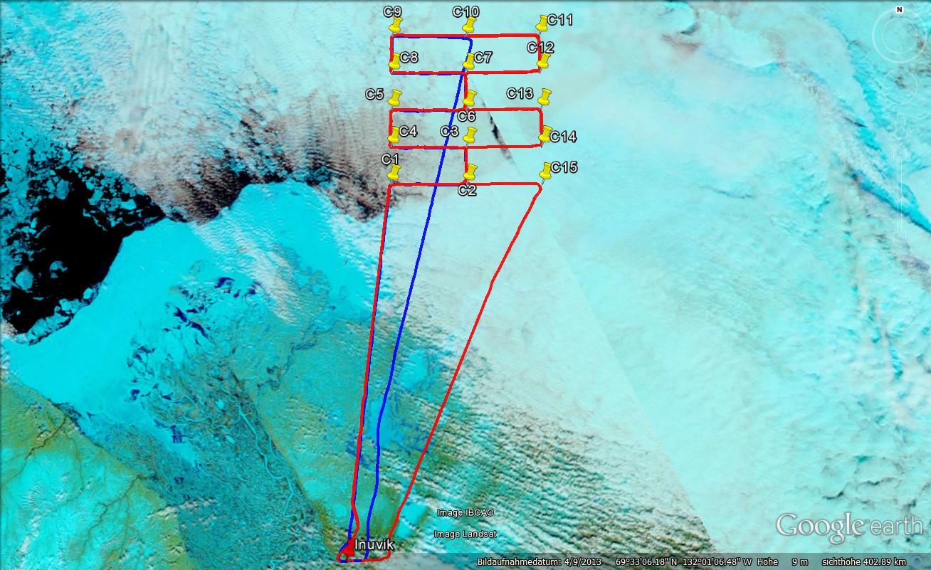
A strong cold front passed Inuvik from Tuesday evening to Wednesday morning causing a temperature drop of 20°C and moderate snow fall. After the passage low level clouds remained above the Beaufort Sea. In Inuvik the sky cleared up during the morning and conditions were ideal for sampling the wide boundary layer cloud field in the north east. The general conditions were characterized by strong northerly winds. In cloud altitude about 40 kn were indicated by the aircraft. Above land additional turbulence made flying a bit bumpy. For today’s mission the flight path of both aircraft was chosen to be like a horizontal raster. Five East-West 20 NM legs only separated by 10 NM build one Box in which we intend to investigate the small scale horizontal variability of the clouds. While Polar 5 does the remote sensing, Polar 6 tried to sample the clouds top along this track as best as possible. A second box was placed just 20 NM eastwards to the first box trying to follow the general flow of the cloud field.
On the way to the first measurement box Polar 5 observed that the scattered clouds get more and more dense forming a closed cloud layer North East of Inuvik already before the Beaufort Sea was reached. The cloud top altitude slowly increased in the beginning. Later only slight changes of about 100 m indicate a very stable and homogeneous cloud layer. Polar 5 in total covered all the 10 cloud legs. No significant differences in the clouds were noticed. Two drop sondes were released, each in the center of one of the two boxes. The lidar did see an almost homogeneous aerosol load between aircraft and cloud with slightly increasing aerosol concentration when flying on the northernmost leg. By eye most of the time a haze layer was visible at about flight altitude.
Polar 6 decide not to enter the cloud deck with cloud tops near 4600 ft before reaching the first box to avoid early icing. The sampling in the area covering pattern was ended after half the first box, because already during the first leg between C1 and C2 icing occurred at the probe pylons and the wings. The icing was serious enough to not go deeper into the cloud deck anymore and rather spend the first areal pattern up to C10 at a safe altitude above the cloud deck. Nevertheless from cumuliform protrusions, little puffs, and cloud/haze segments some sampling occurred between C1 and C10 albeit not at levels where the plane was fully inside the cloud deck. After aborting the second box a stepped profile up to 10,000 ft altitude was flown to sample aerosol and trace gas again. On the way back to Inuvik, the thinning and scattered clouds could be penetrated another time.
: a.ehrlich@uni-leipzig.de
: Leipzig Institute for Meteorology (LIM), Stephanstr.3, 04103 Leipzig, Germany
![]()