| Take Off: | P5 19:41 UTC | P6 19:46 UTC |
| Touch Down: | P5 22:55 UTC | P6 22:27 UTC |
| Duration | P5 3:14 h | P6 2:41 h |
The low pressure system which did not allow a flight on Monday only slowly moved further south west still affecting the local area around Inuvik. Low level clouds remained in and north of Inuvik with some precipitation visible. Satellite images showed a wide area of persistent low level clouds over the entire Beaufort Sea. Having the low cloud with potential icing still above the airport, flight conditions for Polar 6 were still unpromising. Take-off was therefore postponed for 14:00 local. Later cloud ceiling increased and the clouds got thinner so we could start with both aircraft. As it was not sure how deep Polar 6 could penetrate the icing cloud layers the flight plans of both aircraft were split.
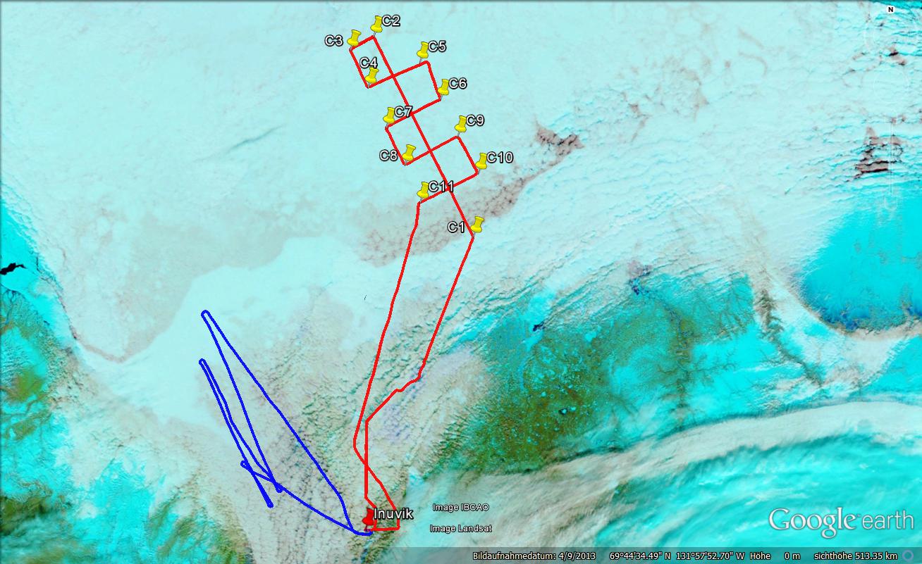
Polar 5 aimed for a comparison flight with the A-Train satellite constellation. Take-off was scheduled that Polar 5 was below the satellite track which today was quite close to Inuvik over the Beaufort Sea. The conditions were almost perfect. No serious cirrus appeared above the measurement area and the boundary layer clouds looked totally homogeneous in all the area. Contrarily to the clouds the surface (ice/open water) changed often what will be a focus when analyzing the data. Polar 5 first flow a straight leg of about 80 NM (45 min) along the satellite path of CloudSat and Calipso. At the time of the overpass Polar 5 reached the end of this leg. Two drop sonde were released on the track. The second part of the flight was a horizontal pattern with different legs perpendicular to the satellite track to extend the spatial coverage of the airborne measurements and to investigate the horizontal variability of the clouds. In the end of the pattern a third radio sound was dropped close to the point where the first sond was released about 2 hours before. The cloud top altitude was very stable during the entire flight as indicated by the lidar signal. Further a quite extended aerosol layer was found just above the clouds. This layer was observed by AMALi during the entire flight above these clouds. After the flight pattern ended Polar 5 returned to Inuvik and could sample the more and more thinning clouds around Inuvik.
Polar 6 did not follow the planned flight pattern along the satellite track as it was not sure how deep Polar 6 could penetrate the clouds because of icing. Instead Polar 6 remained above land within the Mackenzie Delta, where cloud bottoms were lower as above the ocean the clouds were supposed to reach down to the surface. The clouds were attacked from blow, first haven an extended leg along the cloud base. As crew and pilot did notice that the clouds are thinner than expected, some profiles through the entire clouds were flown. Reaching the shore to the open sea the cloud became thicker and with moderate icing Polar 6 did return towards Inuvik. Later again aerosol at cloud bottom and at cloud top aerosol was sampled. With still sufficient flight time Polar 6 did once more return towards North for an additional vertical profile for aerosol and trace gas measurements. The profile did reach up to an altitude of 4,000 ft. On the way home, again some low level clouds could be sampled.
: a.ehrlich@uni-leipzig.de
: Leipzig Institute for Meteorology (LIM), Stephanstr.3, 04103 Leipzig, Germany
![]()